The lost village of Spring Lake

By Jared Olar

Library Assistant

Last week we learned more of the ephemeral history of the “aborted” town of Spring Garden that was platted and surveyed in Spring Lake Township in 1856. This week we will delve into the history of the lost town or village of Spring Lake, which once existed on the shores of Spring Lake in southwestern Tazewell County, down on the Tazewell-Mason county line.

We briefly told of the village of Spring Lake during our series on the unincorporated communities of Tazewell County two years ago. As I wrote at that time, in a “From the History Room” post that is dated 25 July 2019:

“The first community to be established along Spring Lake was the eponymously named unincorporated town of Spring Lake, which once existed on land atop a bluff above the southernmost tip of the lake, along the Tazewell-Mason county line.

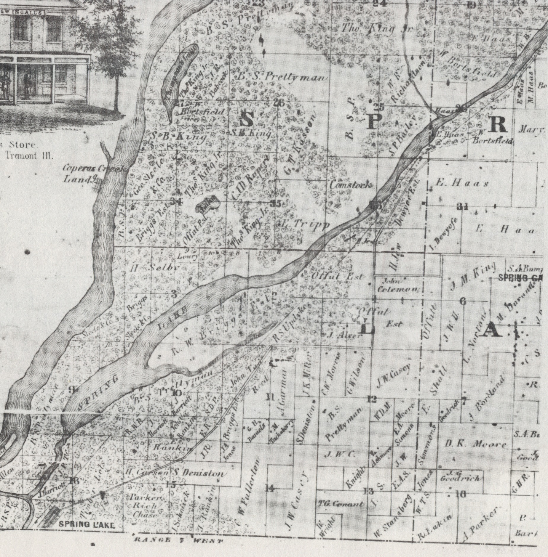
“The late Fred Soady, in his 1979 ‘Preliminary Master List of Settlements in Tazewell County, Illinois,’ describes the erstwhile town of Spring Lake as the ‘southern part of Sand Prairie settlement along Illinois River.’ According to Soady, this settlement had its own post office from 1856 to 1864. In addition, Charles C. Chapman’s 1879 ‘History of Tazewell County,’ page 637, says, ‘The town of Spring Lake, which is located on sec. 16, 22 north, 7 west, was laid out May 15, 1862, by Thomas G. Conant.’

“The town of Spring Lake appears on old county plat maps of Spring Lake Township in 1864 and 1873, and a plat of the town itself was published in the 1873 ‘Atlas Map of Tazewell County,’ page 132. However, the town failed not long after the publication of Chapman’s Tazewell County history – the map of Spring Lake Township in the 1891 ‘Plat Book of Tazewell County’ shows no trace of Spring Lake town. In that atlas, the land that had once been the town is shown as the property of the Pekin & Spring Lake Hunting & Fishing Club. Today the former site of Spring Lake town has been reclaimed by the forest – the only thing there now is a short winding stretch of State Park Road.”

The plat of the vanished town of Spring Lake was published in the 1873 “Atlas Map of Tazewell County.” The town failed not many years later, and the former town site has since been reclaimed by the forest.

Further information on the town of Spring Lake is available from Ken Lacey of the Manito Historical Society, who (as I mentioned last week) told of Spring Lake’s history in a post of 10 July 2019 to the Society’s Facebook page. In his account of the town of Spring Lake, Lacey wrote:

“Located along a line from Havana to Pekin, Spring Lake and Spring Garden were in hopeful anticipation that the proposed Illinois River Railroad would be routed nearby. The railroad surveyor instead routed the railroad near land in which he had a personal interest. This change ended the hopes of the existing village of Spring Lake and destroyed Spring Garden’s hopes of a future. . . .

“Informally laid out as early as 1849, Spring Lake officially was platted in 1852. The village added the Lily Addition which was platted in 1858. Spring Lake was said to have two doctors, four stores, a blacksmith shop, a hotel, and a population of over 125. At the top of the hill was located a grain dealer. When grain needed to be shipped it was bagged and would be tossed on a ‘slide’ which let the bag slide down the hill to the loading dock. Often neighborhood boys jumped on the bags and rode them like a toboggan. This action gave the place the name of ‘Toboggan Hill.’

“A saloon was built on the Tazewell/Mason county line allowing its occupants to walk to one side or the other to avoid jurisdiction of Law officers. The last listed business was in 1868.

“The 1902 ‘Pioneers of Menard and Mason Counties’ said of Spring Lake village, ‘Spring Lake is now a desolate waste; only a few cellars that time has failed to fill with drifting land marks. The places so busy with trade and traffic are now relegated to oblivion.’

“In 1852 Spring Lake was a vibrant growing village which had the possibility of having both a railroad and a steamboat port creating what seemed to be a bright future for the residents of the village. In 1902 just 50 years later the village was being called a ‘desolate waste,’ ‘relegated to oblivion,’ mentioned only as memory in history books.”

It should be noted that there is a discrepancy between Lacey’s date for the original platting of Spring Lake (1852) and the date mentioned in Chapman’s 1879 history of Tazewell County (1862). It is Chapman’s book that is in error – a simple typo of a “6” for the correct “5.”

The complete title of the 1902 book to which Lacey refers above is “Pioneers of Menard and Mason Counties; made up of personal reminiscences of an early life in Menard County, which were gathered in a Salem life from 1830 to 1840, and a Petersburg life from 1840 to 1850; including personal reminiscences of Abraham Lincoln and Peter Cartright.” The author, T. G. Onstot of Forest City, gives a personal recollection of the lost town of Spring Lake on pages 379-383 of his book, which is available online in a digital format.

#ken-lacey, #manito-historical-society, #pekin-and-spring-lake-hunting-and-fishing-club, #pioneers-of-menard-and-mason-counties, #spring-lake, #t-g-onstot, #tazewell-county-unincorporated-communities, #thomas-g-conant, #toboggan-hill

Tazewell’s unincorporated communities: Life on Spring Lake’s shores

By Jared Olar
Library assistant

Over the last two weeks we have taken a look at the Spring Lake Township communities of Talbott and Parkland. This week we will head down to the eastern shore of the eight-and-a-half-mile-long lake that gives the township its name, so we can spotlight the communities along Spring Lake’s shoreline.

Residences line much of the eastern shore of Spring Lake, as shown in this detail from the 2017 plat map of Spring Lake Township.

Spring Lake itself is under Illinois Department of Natural Resources management. Most of the land along the lake’s eastern shore, and a lot of the western shore, is a state park – the Spring Lake State Fish and Wildlife Area. In the alluvial plain of the Illinois River, the lake is relatively shallow, at depth of about 10 feet. It formed naturally long ago when the Illinois River changed its course, but is fed by springs (hence the name, Spring Lake) which keep the water from stagnating.

The western portion of Spring Lake Township in the vicinity of Spring Lake, as it appeared in the 1929 Tazewell County atlas. Note the three country schools, including one on the west side of the lake.

This detail of the 1967 plat map of Spring Lake Township shows the beginnings of Lakewood Terrace Subdivision in Section 2 of the township.

A string of subdivisions along the east shore of Spring Lake are shown in this detail of the 1982 plat map of Spring Lake Township.

Over time several communities have been established on or near Spring Lake’s eastern shore. Today there are two primary stretches of shoreline where people have made their homes. One of them is a grouping of homes that extends in the area along Maple Island Road and Hoff Subdivision Road. The other is further south down the eastern shore – the subdivisions of Lakewood Terrace and Smith Rakestraw. Though the Spring Lake area is chiefly devoted to fishing and hunting, in more recent times a vineyard, known as Mockingbird Vineyards, at 3511 Spring Lake Road in rural Manito, has been established on land approximately between Lakewood Terrace and Smith Rakestraw.

The first community to be established along Spring Lake was the eponymously named unincorporated town of Spring Lake, which once existed on land atop a bluff above the southernmost tip of the lake, along the Tazewell-Mason county line.

The plat of the vanished town of Spring Lake was published in the 1873 “Atlas Map of Tazewell County.” The town failed not many years later, and the former town site has since been reclaimed by the forest.

The locations of the vanished towns of Spring Lake and Spring Garden are indicated in this detail of an 1864 wall plat map of Tazewell County.

The town of Spring Lake is shown in this detail of an 1873 plat map of Spring Lake Township. By the time the 1891 Tazewell County atlas was published, the town had failed and disappeared.

The late Fred Soady, in his 1979 “Preliminary Master List of Settlements in Tazewell County, Illinois,” describes the erstwhile town of Spring Lake as the “southern part of Sand Prairie settlement along Illinois River.” According to Soady, this settlement had its own post office from 1856 to 1864. In addition, Charles C. Chapman’s 1879 “History of Tazewell County,” page 637, says, “The town of Spring Lake, which is located on sec. 16, 22 north, 7 west, was laid out May 15, 1862, by Thomas G. Conant.

The town of Spring Lake appears on old county plat maps of Spring Lake Township in 1864 and 1873, and a plat of the town itself was published in the 1873 “Atlas Map of Tazewell County,” page 132. However, the town failed not long after the publication of Chapman’s Tazewell County history – the map of Spring Lake Township in the 1891 “Plat Book of Tazewell County” shows no trace of Spring Lake town. In that atlas, the land that had once been the town is shown as the property of the Pekin & Spring Lake Hunting & Fishing Club. Today the former site of Spring Lake town has been reclaimed by the forest – the only thing there now is a short winding stretch of State Park Road.

As we noted before, Spring Lake Township affords many opportunities for fishing and hunting. The old Pekin & Spring Lake Hunting & Fishing Club was established to take advantage of those opportunities. At one time most of the land around Spring Lake was the club’s property. The club’s main club house and hotel – which once hosted notables such as Presidents Benjamin Harrison and Grover Cleveland, and, so it is reputed, even Chicago gangster Al Capone – was located at the northern end of Hoff Subdivision Road (County Road 4850E), as shown on the 1910 plat map of Spring Lake Township. The spot was originally called Marshall’s Landing. Betting on horses was another popular past time at Marshall’s Landing at the nearby Radville Racetrack – the track appears on the 1891 plat map of Spring Lake Township.

After the Pekin & Spring Lake Hunting & Fishing Club disbanded, the State of Illinois erected the Spring Lake State Fish and Wildlife Area in its place.

The old club house of the Pekin & Spring Lake Hunting & Fishing Club hosted notables such as President Benjamin Harrison and Grover Cleveland, and was also, it is said, one of Chicago gangster Al Capone’s favorite places to visit. PHOTO FROM THE TAZEWELL COUNTY HISTORICAL STORYMAP

This detail from the 1910 plat map of Spring Lake Township shows the location of the old Spring Lake Club House and hotel.

#al-capone, #benjamin-harrison, #grover-cleveland, #hoff-subdivision, #lakewood-terrace-subdivision, #mockingbird-vineyards, #pekin-and-spring-lake-hunting-and-fishing-club, #radville-racetrack, #smith-rakestraw-subdivision, #spring-lake, #spring-lake-state-fish-and-wildlife-area, #thomas-g-conant